Unique Cell Creation
The WAM GUI works with vector feature classes, which are then converted to a grid based raster representation because they are more computationally efficient. The basin is thus represented as a series of reticular arrays, or grids. The four landscape GIS feature classes shown below are rasterized and overlaid to identify the unique combinations of these inputs. WAM then creates a spatial map and tabular list of every unique combination of the inputs. This creates a set of the basin "Unique cells" from the grids that represent all land source grid cells that have the identical soil, land use, rainzone, and wastewater treatment zone characteristics and therefore are uniquely different from the other cells. Grouping into "Unique Cell" groups allows the source cell sub models to be run only for the uniquely different cell types and not for every cell in the watershed.
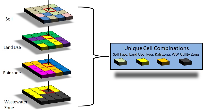
Soil and land use datasets simply contain soil and land use clasifications, respectively. The rainzone layer is used to identify the daily rainfall time series to be used by a particular sub-model with zone in the dataset representing either a Theissen polygon or a NEXRAD cell. Wastewater utility zones are used to determine whether a source cell is within a wastewater utility service area. The constituent loading amounts originating within a source cell depends on the wastewater treatment system present within that cell. If a source cell is identified as being on a centralized wastewater treatment system, then no wastewater is assumed to discharge to surface or ground water from the cell and instead needs to be routed to a treatment system and applied to a sprayfield or RIB at that location. If a source cell is not on a centralized wastewater treatment system, then all wastewater generated within the cell will be discharged to either ground water (septic systems) or surface water (i.e., a local package plant).